Dubai 2040 Urban Master Plan Overview
The Dubai 2040 Urban Master Plan serves as a comprehensive framework for urban development in the Emirate of Dubai, encompassing Metropolitan Dubai and Hatta. It outlines strategies to accommodate population growth (up to 6 million), enhance sustainability (green zones +100%, public beaches +400%), and integrate advanced technologies (autonomous zones, AI), aligning with Dubai’s vision to become the world’s best city for living.
Launch of the Dubai 2040 Urban Master Plan
Launched on March 12, 2021, by His Highness Sheikh Mohammed bin Rashid Al Maktoum, Vice President and Prime Minister of the UAE and Ruler of Dubai, the Dubai 2040 Urban Master Plan represents the seventh structural plan since 1960. Developed over 22 months with input from over 56 public and private sector entities, it builds on prior plans while addressing contemporary challenges such as environmental sustainability and technological advancement. The plan coincides with the UAE’s Year of the 50th and integrates with national visions like UAE Centennial 2071.

As of 2025, implementations include the foundation stone laying for the Dubai Metro Blue Line on June 9, 2025, by Sheikh Mohammed bin Rashid Al Maktoum, enhancing public transport connectivity. Population milestones show Dubai exceeding 4 million residents in August 2025, underscoring the plan’s relevance for managed growth.
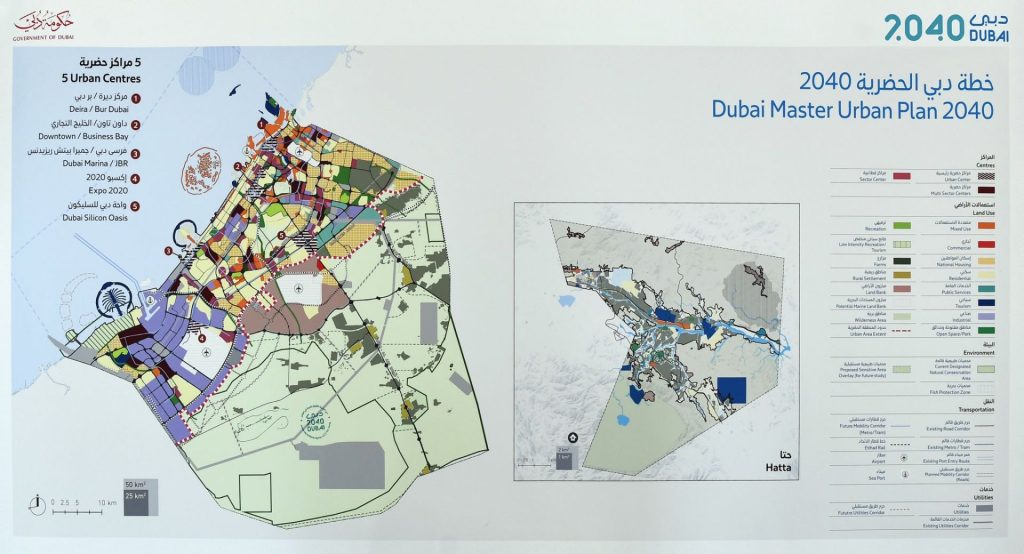
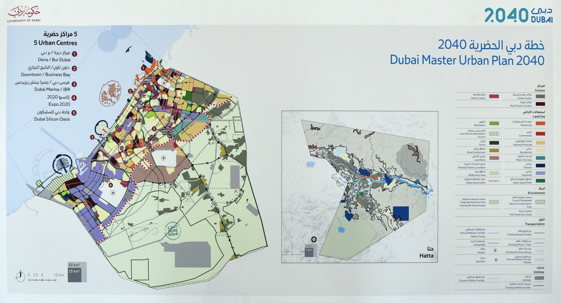
Plan Specifications: Key Components and Structure
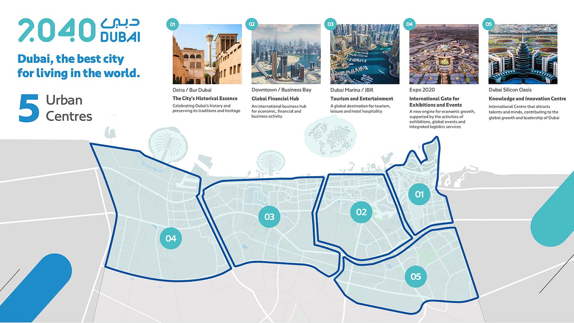
Then plan sets forth five urban centres:
- Deira & Bur Dubai (i.e. Old Town / historic center)
- Downtown & Business Bay (i.e. Burj Khalifa, DIFC, Dubai Fountain, Dubai Creek Harbour, Dubai Autonomous Zone)
- Dubai Marina & JBR (i.e. Marina, Palm Jumeirah, Burj Al Arab & Madinat Jumeirah)
- Expo 2020 (i.e. Dubai South, Jebel Ali) and
- Dubai Silicon Oasis (i.e. International City, Mirdif).
The plan classifies the emirate into four development zones: urban (for densification), peri-urban (mixed-use buffers), rural (wilderness protection), and marine (with development moratoriums). It projects a residential population of 5.8 million by 2040, up from 3.3 million, with commuting workers at 4.9 million and daily visitors at 964,000.
Key land allocations include:
- 1.7 billion square feet for industrial and economic activities.
- 25% increase in spaces for education and health facilities.
- Doubling of green and recreational areas by 105%, reaching 42.8 square kilometers.
- 60% of the emirate’s land as nature reserves and natural areas.
- 400% increase in public beach lengths.
- 134% expansion in hospitality and tourism spaces.
The spatial structure emphasizes a hierarchy of centers to promote compact, transit-oriented development:
| Urban Center | Description/Context |
|---|---|
| Deira and Bur Dubai | Historic core preserving cultural heritage and serving as a multi-sector hub. |
| Downtown and Sheikh Zayed Road | Financial and business district with high-density mixed-use developments. |
| Dubai Marina and JBR | Tourism and entertainment focus, supporting leisure and hospitality. |
| Expo 2020 (District 2020) | Economic growth hotspot for exhibitions, events, and logistics. |
| Dubai Silicon Oasis | Knowledge and innovation center attracting tech talent and high-tech clusters. |
| Jebel Ali (post-2040) | Future multi-modal industrial and port-linked hub. |
Additional features include green corridors connecting parks and reserves, sustainable utilities like district cooling and waste-to-energy, and an integrated geospatial data platform for smart city management.
- Annotations: Urban centers prioritize densities peaking at transit nodes; 55% of residents within 800 meters of public transport stations; high-tech corridors link Silicon Oasis to foster AI and robotics ecosystems.
What to Expect: Initiatives, Sustainability, and Tech Integration
The plan advances sustainability through closed resource systems, emission reductions via active travel, and aquifer protection. Mobility initiatives include shaded pedestrian and cycling networks, public transport expansions (Metro, light rail, buses), and freight along Etihad Rail, aiming for 20-minute access to daily needs and 30-minute commutes to jobs.
Tech integrations support smart cities:
- High-tech/STEAM clusters for innovation, aligning with broader ecosystems like SpaceX-inspired direct-to-cell services or Starlink for enhanced connectivity in urban centers.
- Future-proof systems for autonomous vehicles, including potential Tesla RoboTaxi deployments in transit-oriented zones.
- EV infrastructure growth, with Supercharger networks expanding to support decarbonization and sustainable transport targets.
Partnerships involve the Supreme Committee for Urban Planning, Dubai Municipality, and entities like DEWA for clean energy goals (75% by 2050). Phase II initiatives (ongoing in 2025) include urban farming, heritage preservation, a 20-minute city policy, and pedestrian masterplans.
| Fact | Details |
|---|---|
| Sustainability Targets | Double open spaces; 60% nature reserves; reduced emissions through transit focus. |
| Economic Focus | High-tech sectors; 1.7B sq ft industrial land; alignment with D33 for AED 32T economy by 2033. |
| Mobility Goals | 55% population near public transport; integrated EV and autonomous systems. |
| Social Benefits | Affordable housing; inclusive communities; enhanced quality of life. |
History of Dubai Urban Master Plans: From 1971 to 2071
Dubai’s urban planning history reflects a progression from modest beginnings to ambitious global aspirations, with five foundational plans preceding the Dubai 2040 Urban Master Plan. The 1960 Dubai Master Plan addressed a population of 40,000 within a built area of 3.2 km², focusing on basic infrastructure around the creek. By 1971, the updated Dubai Master Plan expanded zoning to 80 km² for 80,000 residents, accommodating early growth.
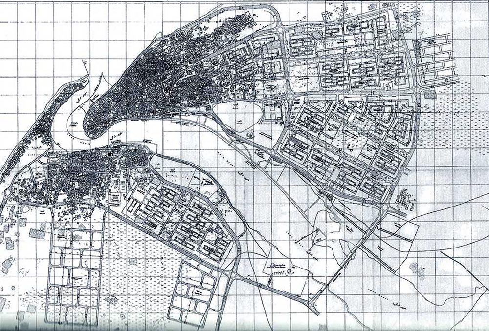
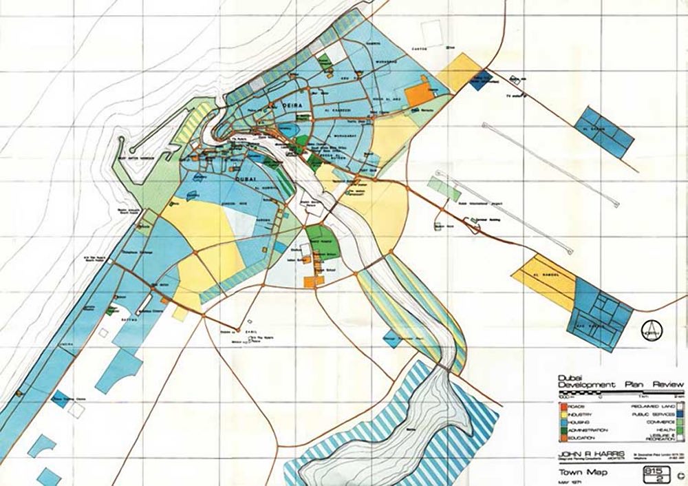
The 1985 Dubai Structural Plan scaled urban areas to 367 km² amid a population surge to 370,000, emphasizing structural frameworks. In 1995, the Dubai Urban Area Structure Plan further enlarged urban zones to 1,035 km² for 674,000 people, integrating mixed-use developments. The 2012 Dubai 2020 Structure Plan extended urban areas to 1,335 km², supporting 1.905 million residents and introducing development zones from the coastline to E611. These plans collectively established zoned, built, and urban areas as core concepts, providing the spatial and regulatory backbone that Dubai 2040 enhances through sustainability, tech integration, and projections for 5.8 million residents by 2040.
Rough Timeline of the Dubai 2040 Urban Master Plan
| Milestone | Date |
|---|---|
| Launch | March 2021 |
| Phase I Infrastructure (Metro expansions, green spaces) | By 2025 |
| Phase II Initiatives (Urban centers enhancement, 20-minute city policy) | Ongoing 2025-2030 |
| Carbon Emission Reduction (30% from 2015 levels) | By 2030 |
| Renewable Energy Share (25% of total) | By 2030 |
| Full Implementation | By 2040 |